If, like me, you view owning a car as one of the deepest money pits of modern everyday life, you need to make sure that you find a place to live that's at the very least near public transport, but ideally also near a grocery store, a pharmacy, a hairdresser, a gym, or anything else really that you in particular make frequent use of. A lot of things you can also get delivered or do by yourself at home, but you definitely won't have the same flexibility or convenience.
Now, car-dependence is often treated as a city vs countryside issue, but in my mind that raises the question of where exactly you should even draw the line between these two things. Not to mention the existence of suburbs, that are less common than in America, but can still be found even on the edges of Swedish cities. Those are technically part of a big city with lots of amenities, but in practice walking to them turns out to be very inconvenient, although maybe good for your health!
So what is the "normal" way of determining walkability? Well, normally you just look up the address on Google Maps and see the kinds of places I mentioned earlier that are around it. You might measure the most important distances, but for the most part it's very based on intuition, which means it does not scale to comparing thousands of apartments and being able to find the best one. So clearly we need some sort of methodology to determine this objectively, but what does that look like?
First, we have to figure out what we can measure objectively and realistically. On the Bostadskvant landing page, I use grocery stores as the prime example. Firstly because for the most part, most people have to go there at least weekly, and secondly, because the vast majority of Swedish grocery stores belong to just a handful of chains (ICA, Willys, Coop, etc.), which makes it relatively easy to search for them on OpenStreetMap. So they are very centralized. The most extreme end of centralization would be Systembolaget, since they literally have a mandated monopoly, so of course I'm taking advantage of that by turning it into its own category!
Gyms are where it starts to get tricky, because while there are chains here as well (Nordic Wellness, Fitness24Seven, STC, etc.), many of them are independent, so it's less centralized and they're not as easy to identify. Luckily though https://gymkarta.se/ provides a separate list that's a lot more comprehensive than OpenStreetMap. What I consider to be the extreme end of decentralization are hairdressers, because there are no large chains in this particular sector that I know of. And trying to systematically search for them turned out to be so unreliable that I dropped them from the dataset entirely, and the same thing goes for dentists.
I also didn't know when I started if finding bus stops and train stations would end up being reliable, but it does seem to be the case as far as I can tell. Do feel free to use the [feedback form] if you find any mistakes regarding this, or anywhere else. However one obvious thing does need to be said, which is that mere distance to public transport tells you relatively little about its value. The value comes from frequency and proximity to other stops, which is probably also possible to measure, and I suspect Trafiklab’s GTFS Sverige could be a good starting point for that, but that might be a topic for a separate report.
So now we've defined a few places that we want to measure the distance to, but I also need to clarify that I chose to measure straight-line distance rather than actual walking distance, because it's significantly easier to compute. That's also why I'm calling it the "Amenity Index" rather than the "Walkability Index" or similar, because if you were to find yourself on the wrong side of a railway or river, that could absolutely skew results. Regardless, I found that the places neatly fit into five different categories, and I assigned each of them a percentage. (See image below) Like I said, I deem groceries to be the most important by far, then public transport and lifestyle still pretty important, and then health and retail slightly behind that. All of the subcategories contribute equally to the total category score.
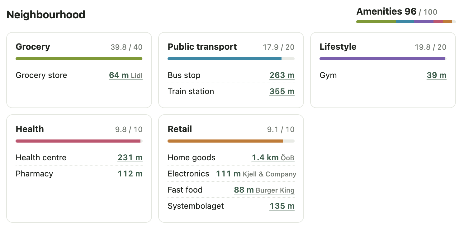
So how does a distance turn into a score? How does "64 m" become "39.8/40" in the grocery case? For this I'm using a kind of bell curve (Cauchy), whose exact shape is determined by what I call "half distance". This is the distance at which any given place gets a 50%. For grocery stores for example, this value is 1km, but every subcategory has its own half distance. It's basically the line you have to draw between "convenient" and "inconvenient", and you can probably argue a lot about it. I tried not to overthink it however, since it's just meant to give people a rough idea of walkability.
One further refinement I did want to make though was to reward apartments with several options. For example, having one grocery store near you provides most of the value, but having another one still provides extra value, since it might have different products or different discounts you might want to take advantage of. Therefore, the closest grocery store accounts for 70% of the total, the second for 20%, and the third for 10%, to account for this "nice to have" as well.
I tried this system out and found that it generally seems to align well enough with my intuition, but to really stress test it, let's look at a place that's at the frontier of minimum population with maximum amenity scores.
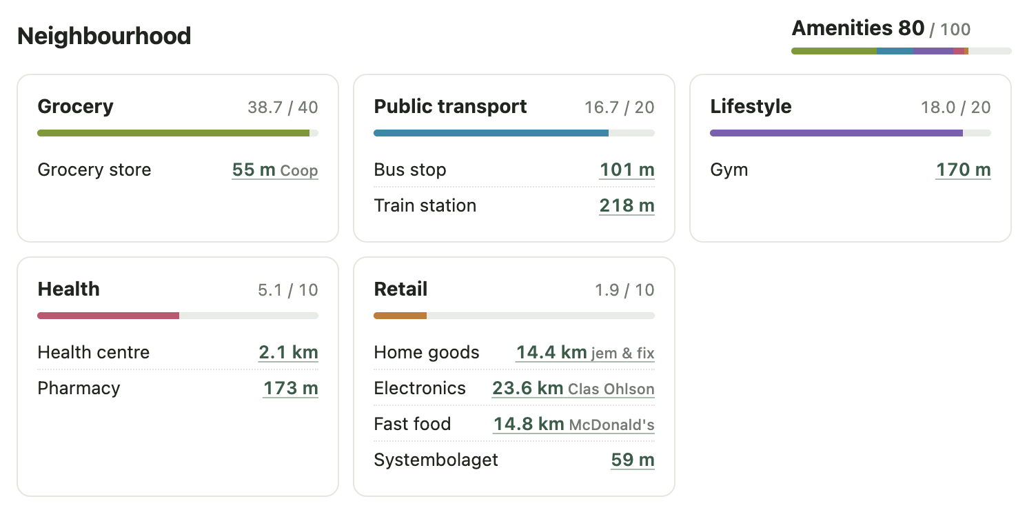
The above image shows the scores for a central apartment in a small town of under 5000, ~200km from Stockholm called Säter. For reference, this one comes in at 80, while the median for all of Bostadskvant is 61. It is more or less right next to all but four amenity subcategory places, but you can of course question if that alone is really enough to be "~80% as good" as central Stockholm. If you're curious, the best address in all of Sweden, though not one you can live at, is Drottninggatan 50 in Stockholm and scores 98.8. However, central Stockholm will also have a comparably infinite amount of restaurants, bars, clubs, and just general "events" of all kinds. The amenity index only measures the essentials, not the experience potential (upplevelsepotential).
I think that is totally fine though, since it intuitively feels like population size should be strongly correlated with experience potential, and the people who value it highly are probably less interested in optimizing where they live on a national scale anyway, which is exactly what Bostadskvant aims to help with. Finding easily obtainable apartments in low demand areas that are still great places to live.